Opting Outside on America's Public Lands
Data from Outdoor Alliance's GIS Lab
At REI’s encouragement, millions of Americans decided to forego the shopping malls for the fresh air on Black Friday last year.
Last Thanksgiving in DC, I hiked at Great Falls National Park on the Billy Goat Trail. With friends and their 5-year-old daughter, we scrambled along the rocky path, pointed out some of our favorite spots to climb, and tried to identify plants and bird songs for our youngest hiker. This popular trail winds along the bluffs overlooking the Potomac River, with world-class paddling, decent cliffs for climbing, and some of the area's most popular hiking trails. It’s a landscape so majestic and rich in recreational opportunities that you’d be forgiven for forgetting that you’re just a 20-minute drive from the nation’s capitol and its 6 million residents.

Enjoying nearby public lands last November.
Like 80% of Americans, I live in a city but love to get outside on weekends. Within an hour’s drive of Washington DC, you can enjoy more than 150 thousand acres of public land. If you also skipped the mall and hit the trail last year, you probably did so within a few hours’ drive of your house.
In our busy lives, the outdoors are an escape, a way to recharge and reconnect to what matters. Most of us don’t spend a lot of time thinking about how these places came to be, how they are managed, or who sets the rules about where we can bike, hike, camp, or climb. We assume these places will exist, and we will have access to them. Behind the scenes, there are dozens of organizations that work to protect public lands, and our outdoor adventures on them. Outdoor Alliance is a coalition of 7 different recreation advocacy groups—Access Fund, American Alpine Club, American Canoe Association, American Whitewater, IMBA, Winter Wildlands Alliance, and The Mountaineers—who are working together to advocate for public lands and protect access to hiking, mountain biking, camping, paddling, climbing, and backcountry skiing.
The growth of big data, including tools like Strava and Adventure Project sites, have been revolutionary for how advocacy groups work to protect the outdoors. Along with helping you find new places to ride or camp or ski, this data has been transformative for helping us protect and improve recreation on public lands. Being able to show detailed maps of where people are skiing or climbing or hiking means that we can find landscapes that need protection, and better advocate for resources like trailheads, bathrooms, parking, and maintenance. They also help us understand where people go when they opt outside.
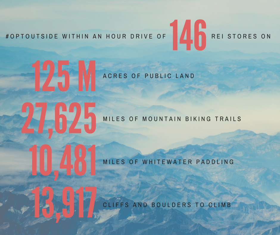
REI’s 146 stores around the country are within an hour’s drive of 125 million acres of public lands. These public lands include places like Rocky Mountain National Park (just 40 miles from the REI in Boulder, Colorado) and Mt. Baker-Snoqualmie National Forest (just 50 miles from downtown Seattle’s REI). If you include state and private land, REI stores are within a short drive of almost 28,000 miles of mountain biking trails, over 10,000 miles of whitewater paddling, and nearly 14,000 climbing areas. That’s a lot of adventure – and a lot of chances to opt outside without going far from home.